Saturday, December 17, 2016

Major cold blast on the way tonight thru Monday...

A strong, arctic cold front will move through the area late this evening or early tonight. Northwest to North wind will increase to 25 mph sustained, with frequent gusts to 35 mph from after 10-11pm today through about 12 Noon on Sunday, then decrease somewhat into the 15-25 mph with gusts to 30 mph range during the afternoon on Sunday.

Actual air temperatures will fall from the lower 50s at Midnight tonight into the 30s during the pre-dawn hours on Sunday and will then remain in the 30s for most of the daytime hours. Temperatures will continue to fall into the middle to upper 20s by dawn on Monday, and then readings will only rebound into the 30s across most of the local area during the daytime hours on Monday once again.

Wind chill values will fall into the teens early on Sunday and continue mainly in the teens or lower 20s through mid-morning on Monday, then rising into the upper 20s by Monday afternoon.

Temperatures will moderate across the area on Tuesday, with morning low temperatures near 30 and afternoon high temperatures near 50 degrees for most of the area.

We do not expect any wintry precipitation in association with this cold front across the local area. 

Monday, December 5, 2016

First Arctic Blast of the Season Later This Week...

A strong, arctic cold front will blast into the local area late on Wednesday evening into the pre-dawn hours of Thursday, bringing much colder conditions to the region for the end of the week into at least early this weekend.

On Thursday, North winds will increase to 15-20 mph with frequent gusts to 30 mph beginning in the pre-dawn hours and continuing into much of the daytime hours. Temperatures will fall from the upper 40s or low 50s during the pre-dawn hours of Thursday morning, through the 40s and into the 30s during the day on Thursday, reaching freezing by late Thursday evening. Wind Chill values will be in the 20s to lower 30s throughout the day on Thursday.

On Friday, morning lows will be in the middle to upper 20s. The temperature will have fallen to around freezing by 10-11pm on Thursday night, and stay at or below freezing through about 9-10 a.m. on Friday, resulting in a very hard, long duration freeze across the area during the Thursday night/pre-dawn Friday into early Friday morning period. Wind chill values will mainly be in the teens at the morning rush on Friday, and then the 20s to lower 30s throughout much of the remainder of the day. The high temperature on Friday will struggle to reach the middle 40s, even with nearly full sunshine.

Another freeze is likely on Saturday morning, but not as hard as on Thursday night/Friday morning, with minimum readings of 30-32 degrees early on Saturday. Temperatures will moderate during the day on Saturday, with high temperatures climbing back into the 50s.

No wintry precipitation is forecast with this event. In fact, no significant precipitation of any type is expected in association with the frontal passage. 

Saturday, September 24, 2016

Wetter, Cooler Weather Instore In the Coming Days...


A cold front and upper level weather disturbance will bring numerous showers and scattered thunderstorms to the local area mainly from Sunday afternoon into much of the day on Monday.

Widespread total rainfall of around 1 inch appears likely especially from near 12 noon on Sunday through the early afternoon hours on Monday. Localized higher amounts of 1-2 inches are possible in spots, especially associated with any concentrated areas of thunderstorms during that same time period.

Temperatures will also cool down considerably behind the cold front during the early and middle part of next week. High temperatures will mainly be around 80 degrees on Monday, and in the upper 70s on Tuesday, rising back into the lower 80s on Wednesday. Morning low temperatures will likely drop to around 60 degrees on Wednesday morning and will be in the low to mid 60s during the rest of the early and middle part of the week.

Ahead of the more widespread rainfall activity for later Sunday into Monday, scattered showers and isolated thunderstorms can be expected across the area today, mainly during the afternoon and early evening hours. This activity may be slightly more numerous compared to yesterday. 

Thursday, May 19, 2016

Please see twitter for real time weather updates today

We are not currently posting on the blog regarding today's weather situation.   Please refer to live/real time updates on twitter.

Tuesday, May 17, 2016

Daylight hours today will be quiet for the metro. The time to watch is after Sunset and into tonight...

Scattered to numerous thunderstorms are expected to form well to the West/Northwest of the local area (further out over the Hill Country) late this afternoon, generally after 3pm. Some of this activity may move and/or develop Southeastward into at least parts of the local area after Sunset today into early tonight/pre-dawn Wednesday (generally before 2-3am on Wednesday).

The exact track of the strongest and most organized thunderstorm activity late this evening and tonight is still somewhat in question.  There is a moderate possibility that the strongest and most organized thunderstorm activity will turn more toward the South/Southeast prior to approaching the I-35 corridor late this evening.  If this occurs, the strongest and most widespread storms would likely remain to the immediate West of the local area later this evening into tonight, with more "general" shower and thunderstorm activity across the local area.


Several of the short-range/high-resolution forecast models have recently come into agreement with this possibility, as shown in one instance below:


In short - it will be difficult to assess the likely future movement of the more organized and stronger thunderstorm activity until closer to (or even shortly after) the time that it actually forms further to the West late this afternoon.  At that time we'll be able to gauge the eventual organization and movement much more clearly.

To summarize:  While there is a good chance of scattered showers and thunderstorms locally after Sunset today and into at least the first half of tonight, some question remains as to where the strongest, most organized storms will track.  If any stronger, more organized thunderstorm activity does move and/or develop into the local area late this evening or early tonight, areas of locally heavy rain are likely, and a few stronger storms could also produce strong, gusty winds and possibly some hail in some parts of the area.  Again, this would be from after Sunset today through about 2-3am on Wednesday for the local area.

We will continue to monitor the evolution of activity later today and issue updates as warranted.

Monday, May 16, 2016

An Update on Thunderstorm Potential for Tuesday, 5/17/16 (into pre-dawn Wednesday, 5/18/16)

The potential exists for thunderstorm activity across at least some parts of the local area during two specific time periods on Tuesday. The first is on Tuesday morning, and the second is after Sunset on Tuesday evening, into Tuesday night.

...Tuesday Morning...
Scattered thunderstorms are expected to develop in far southwest Texas and adjacent portions of far northwest Mexico later this evening into early tonight. It is possible that some of this activity may move and/or develop far enough toward the East to reach parts of the local area on Tuesday morning, but this is not a certainty at this time. At this time we would place the probability of this happening at around 30 percent. If any thunderstorms do move into the local area from the West on Tuesday morning, it would most likely occur sometime from near sunrise through possibly 10am. Brief, heavy downpours of rain would be the primary concern with any thunderstorms during that time, as well as lightning.

...After Sunset on Tuesday Evening, Into Tuesday Night...
A somewhat higher chance of thunderstorm activity appears to be shaping up for the local area late on Tuesday evening (after Sunset) into Tuesday night. Thunderstorms are expected to form out over the Hill Country late on Tuesday afternoon. Some of this activity may move and/or develop into the local area after Sunset, into mainly early Tuesday night/pre-dawn Wednesday (mainly before 2am on Wednesday).

There is some uncertainty regarding the Tuesday evening/Tuesday night time period locally, as the bulk of the thunderstorm activity may form and/or move in such a way as to remain to the immediate West of the local area. It will be difficult to assess this potential until sometime during the day on Tuesday. We will continue to assess the latest trends and issue updates as this becomes more clear.

If thunderstorm activity does move or develop into the local area on Tuesday evening after Sunset, it would likely result in areas of locally heavy rainfall, and a few stronger storms could also produce strong, gusty winds and perhaps some hail in some parts of the area. Again, this potential will be highest from after Sunset on Tuesday evening through about 2am on Wednesday morning across the local region.

Sunday, April 17, 2016

Please see our twitter account for updates on the current weather situation...

There is not currently a blog post concerning the present weather situation.  For updates, please visit us on twitter!

Monday, March 7, 2016

Update on Primary Weather Concerns/Timing for the Greater Austin Metro Area...

We've seen quite a bit of chatter on social media and other outlets suggesting a threat of severe weather for the Austin area today or tonight.  While this cannot be completely ruled out, it doesn't appear very likely to happen.  

The primary reason that we expect the threat of severe weather to remain further to the North and/or West of the local region today and tonight is due to the continued presence of a strong "capping inversion" across the local area. While there will be a weak weather disturbance that will move near or through the local area late tonight and early Tuesday morning, it doesn't appear that the disturbance will be strong enough to "break the cap" and allow for extensive severe thunderstorm development locally.

We would generally expect to see some increase in showers and possibly a few isolated thunderstorms later tonight into early Tuesday morning as the weather disturbance mentioned above passes over or near the area, but this activity would not likely pose a severe weather threat locally based on present indications.  We'll keep an eye on it though, and will issue any updates as warranted.

Our primary concern for potentially strong to severe thunderstorm activity across the local area continues to be from late Tuesday evening into Tuesday night and the pre-dawn hours of Wednesday morning.

The image below shows a computer model simulation of the weather radar valid at 9pm tomorrow:


As you can see, scattered to numerous thunderstorms, some of which may be severe, are forecast to be underway and/or increasing to our West, and this activity is likely to move East/Northeastward, possibly impacting significant portions of the local area near Midnight tomorrow night, as shown in the image below:


When looking at simulated radar forecasts, it's important not to take the position and intensity of the storms literally - just look at the general idea, which suggests increasing storms to our West in the evening hours on Tuesday, arriving locally by around Midnight (give or take an hour, roughly).

The primary concern with any strong to severe storms on Tuesday night (locally) would be strong, gusty winds and possibly some spotty hail (although the more significant hail threat would likely be higher further to our West and earlier in the evening hours).

Another concern for Tuesday night into early Wednesday morning across the local area has to do with locally heavy rainfall, which could lead to flooding problems in low lying or poor drainage areas across at least some parts of the region.


Of the average 2-3 inch rainfall that we expect to occur across most of the local region through Friday (as shown on the image above) about 50-60% of it is likely to occur on Tuesday night into early Wednesday morning (generally from 9pm Tuesday through 6am Wednesday).

If you have any travel plans late Tuesday evening through early Wednesday, especially in areas with low water crossings, use caution and allow for extra travel time.  If we do see heavy rainfall that causes impacts to some low water crossings, those impacts could linger well into the morning rush on Wednesday, even 3-4 hours after the primary rainfall has ended.

Stay tuned here and on twitter and we'll keep you updated...

Sunday, March 6, 2016

A Wet Week Ahead for Southcentral Texas...


Several periods of showers and thunderstorms are likely across the local region this week.  The above image shows the forecast total rainfall - on average - for the region for Monday through Friday.  I point out "on average" because this doesn't account for pockets of locally heavier rainfall produced by thunderstorm activity, which is certainly possible in at least some parts of the area.

Precipitation will start out relatively light (in the form of drizzle and/or patchy showers) on Monday with the potential for heavier showers and thunderstorms developing by later Tuesday into early Wednesday.  Additional showers and storms are then possible on Thursday and Friday, with Friday likely to be the more active of the last two days (locally heavy downpours are possible at times again with the activity on Friday).

We do have some concern for potential flooding of low lying and poor drainage areas (especially low water crossings and the like) across at least some parts of the local area during the period late Tuesday evening into the pre-dawn and early morning hours of Wednesday, as illustrated on the graph below:


The small white squares on the graph show the average rainfall forecast between the NAM and GFS computer models.  As you can see, the period 9pm Tuesday thru 6am Wednesday is "targeted" as particularly active rainfall wise, and it is important to keep in mind that higher totals are possible with thunderstorm activity during the same time period.

We agree with that general timing for possible locally heavy rainfall based on the latest forecast trends that we're seeing.  With that in mind, we'll need to keep an eye on the Wednesday morning commute for possible issues with low water crossings, etc.  It is possible that the heaviest rainfall will occur to the East of I-35 during that specific time period, so folks in the Bastrop and Lockhart areas will particularly want to keep an eye on the low water crossings early on Wednesday morning.

As far as "severe" weather (i.e,. damaging winds, large hail, isolated tornadoes, etc.) is concerned, while we cannot rule it out across some parts of the local area, the situation is far from certain and is somewhat complex.  We'll attempt to explain why below...

As of now there appear to be two time periods that we need to watch for the possibility of strong to severe thunderstorm development across the local area:
(1).  Late Monday night into early Tuesday morning
(2).  Late Tuesday evening into Tuesday night 

At this time, we do not expect significant strong or severe thunderstorm activity locally on Tuesday morning (period one) due to the presence of a strong "capping inversion" across the local area.  This should tend to limit thunderstorm development overall across the local area during that time period (and this trend is also supported by the computer model data shown on the above graph).  If an isolated strong or severe storm were to be able to develop during this time, it could produce strong, gusty winds and hail on at least an isolated basis in some parts of the local region.

The second time period appears more favorable for at least isolated to scattered strong to severe thunderstorm activity across the local area as a strong upper air disturbance will likely help "break the cap" to our West, which could lead to more extensive thunderstorm development locally late on Tuesday evening or early on Tuesday night.

The image below shows a simulated weather radar forecast (by the NAM computer model) valid at 6pm on Tuesday.  As you can see, it suggests that scattered strong thunderstorm activity will be developing around or shortly after that time to our West, out over the Hill Country:


This activity would then likely move and/or develop toward the East/Northeast and some of it could impact the local region mainly after 9pm on Tuesday, into Tuesday night.  The primary concerns for any locally severe weather by that time would likely be in the form of strong, gusty winds and spotty hail, along with the heavy rainfall threat noted earlier in this post.

So, to sum things up:  Most everyone can expect some much needed rainfall across the area this week.  We need to keep an eye on the period from late Tuesday evening into early Wednesday morning for possible low land flooding in at least some parts of the area (especially in low water crossings and especially along/East of I-35).  While we cannot rule out some strong to severe thunderstorm activity (mainly during that same late Tuesday-early Wednesday period), there are more variables at play there, and we need to watch the latest trends for more clues on what is likely to happen.  Friday is another day to watch for possibly locally heavy downpours in at least some parts of the area.

Stay tuned here on the blog as well as on twitter and we'll keep you updated throughout the week...

Wednesday, February 10, 2016

Williamson #Travis #Hays #Caldwell #SCTX_Aware Elevated Wildfire Concern for 1200 pm - 6:00 pm 10 Feb 2016 -- RF

Elevated WILDFIRE Concern 
Effective From 12:00 pm– 6:00 pm 10 February 2016

*****Burn Bans Are In Effect for the following Counties in the SCTX_Aware monitor area; Caldwell, Travis and Hays*****

Elevated Fire Weather is forecasted for the SCTX Area today 10 Feb 16; to include all counties under our monitor system. Williamson, Travis, and Hays.

Most of the concern will be along and West of the IH35 Corridor of the SCTX_Aware monitor area, however concerns for the remainder of the SCTX_Aware area can’t be totally ruled out.

Elevated conditions will began around the 12:00 pm, through 6:00 pm, when humidity and wind conditions will raise/lower, respectively. 

Winds will be below the established critical threshold of above 20 mph but will be mainly out of the South at 10 – 12 mph. during the period, with slightly higher gusts possible. Humidity levels should remain above establish critical levels of 20% or lower but will still be around the 22 – 25% during the concern period

Care should be taken to conduct no outdoor burns, or activities that could produce a wildfire situation.

Again this is a Elevated Wildfire Concern for today from 1200 -1800 hrs 10 February 2016.


We will be monitoring the situation --- RF/RW SCTW_Aware


Wednesday, February 3, 2016

Planned Road Closures on I-35 at Yarrington Between Kyle & San Marcos


TXDOT will close the main lanes of I-35 at Yarrington Road (between Kyle and San Marcos) from 8pm-5am on February 7th-11th (this coming Sunday through next Thursday) to allow demolition of the old Yarrington Road bridge.

During the closures, traffic will be diverted onto the access roads as follows:

Northbound traffic on I-35 will take Exit 210 toward Yarrington Road. Northbound traffic will re-enter the highway at the entrance ramp north of Yarrington Road.

Southbound traffic on I-35 will take Exit 210 toward Yarrington Road. Southbound traffic will re-enter the highway north of the Blanco River.


Sunday, January 24, 2016

Trying to Make Your Way Back to Austin from D.C.?


The big blizzard ended as expected overnight, but has left behind a huge mess that will take, in some cases, days to fully clean up.  Above is an image showing total snowfall across the northeast into southern New England from this event. Below is the same image, zoomed in on Washington DC at the center:


As feared/expected, as much as 2-3 feet of snow fell across much of the DC area, northwest into western Maryland and northcentral Virginia.  Drifts of snow have buried cars like toys across the region as well.

So, the $64,000 question - "When can I get out of D.C.?!?!?!"  As of this writing, Washington Dulles International Airport says that there are no departing flights scheduled for today, as they'll need the entire day to recover the airport.  You can check the Winter Storm page of their website for later updates.

The same is true for Washington Reagan National Airport, with no departures planned for today.  You can view the airport status on this page.

Snow removal operations at Washington Reagan Airport 1/24/16
If you had flights scheduled out of area airports today, the best bet is to check with your airline on available options as soon as possible.  Remember, the early bird catches the worm, and with hundreds of flights having to be rescheduled, you'll want to be as close to the front of the line as possible to ensure you can get out once regular airport operations resume.

With air travel snarls likely to last into early this week, another option might be to take Amtrak to another city where airport operations will get back to normal faster, but you'll have to wait until at least Monday to use this option out of DC, as Amtrak is not running service there today.  Outside of the DC area, Amtrak is operating on a "limited" schedule today, and should see increased operations on Monday.  Again, you'd want to check with your airline for options in outlying areas first, and then see if Amtrak can help you get there on Monday or Tuesday.  The link to the Amtrak bulletin above pertains to Sunday, 1/24/16 only. For later updates to the Amtrak system status, you can use this link.

So if you're still hunkered down - hang in there - the Lone Star State awaits your arrival as soon as you can get back safely!

Friday, January 22, 2016

Snow Accumulation is Picking Up in D.C.

The snow began in D.C. right on schedule around midday and continues to increase at this time.  This trend will continue into tonight and Saturday, and we still expect nearly 2 feet of snow on average across most of the region, with higher amounts possible in spots:


When you combine the heavy snow with strong, gusty winds, blizzard conditions will occur at times, with widespread blowing and drifting snow likely to continue across the region through Sunday.

Hopefully you're hunkered down somewhere by this point, and ready to ride this thing out.  It is rapidly getting to the point where it is unsafe to be outside, and this condition will only worsen with time.

Our next primary focus will be on letting you know when you will be able to think about getting back to Austin, but we probably won't be able to start looking at that angle until sometime tomorrow, once we see how severe conditions become across the region, and gauge the fallout at major airport hubs all along the Eastern seaboard.

Blizzard Getting Underway in Virginia - Will Reach DC by Tonight

No major changes to the snowfall forecast as a blizzard unfolds across the mid-Atlantic and northeast U.S. today through Sunday.

We continue to expect some of the highest, if not the highest, snowfall totals to occur very near the Washington/Baltimore area, with 1-2 feet likely on average, and localized amounts of 2-3 feet possible.

The images below show the latest total snowfall forecast maps for the region as a whole, and then a zoom-in on the Washington DC area:


Snow has already started to fall in western Virginia early this morning.  Light snow will begin in the Washington DC area by late morning or midday, and will dramatically increase this afternoon and evening, with blizzard conditions likely by this evening and into tonight.

Travel will become impossible across most of the above mentioned areas starting this evening and increasing in severity into tonight and Saturday.  Strong, gusty winds will continue into Sunday, which will cause continued blowing and drifting well after the accumulating snows have ended.

If you're already in the DC area we suggest finalizing your plans to "hunker down" through at least Monday.  You still have most of the morning and midday a hours today to grab any last minute supplies.  We would also suggest taking out some cash from an ATM, in case power outages cause problems with "plastic" currency during the weekend, but that may be a mute point, because it will be very difficult or impossible to move about the area anyway based on present expectations (but it never hurts to be prepared).

Thursday, January 21, 2016

Washington DC Area Winter Storm Update

In case you missed the original post this morning, we're following the major winter storm that is headed toward the mid-Atlantic and northeast U.S. for the benefit of Austinites that regularly travel between the capital of Texas and our nation's capital.

Not much has changed since the morning update, and you can still refer to that post for additional details, but we did want to provide the latest storm total snowfall forecast for the region:


...as well as for the Washington DC/Baltimore area specifically:


The amount of snow currently forecasted for the Baltimore/Washington area is approaching/exceeding record levels (#1 in the record books is a 28 inch snow storm in January of 1922, and #2 is a 20.5 inch snow storm in February of 1899).

Regardless of the exact total from the upcoming system, major impacts will be had on all ground and air transportation throughout the region.  The greater Washington DC transportation system (METRO) has already announced closings for the storm, and many airlines are also in the process of cancelling flights and/or issuing waivers.

Because so many airport hubs will be impacted by this storm, it will be important to check your flights ahead of time for cancellations and/or delays from tomorrow through at least Monday.

If you have already arrived in the DC area or will arrive early Friday, make sure that you have a back-up plan to include possibly becoming "stranded" until Monday.

Powerhouse Winter Storm to Impact the Northeast/Mid-Atlantic

Here at SCTX Aware, we don't talk about storm systems in other parts of the country very often, as our focus is primarily on the greater Austin Metro area.  We are, however, paying close attention to the impending major winter storm for the Northeast U.S. tomorrow through Sunday for two primary reasions:  (1).  many Austinites work for the government and frequently travel to the Washington DC area, and (2).  air travel will likely be impacted nationwide by this system.

The impacts from snow from this system will be very high to extreme for a large portion of Virginia, northeast into the Baltimore/Washington DC area, as shown in lavender on the image below (courtesy of our partners at WeatherGuidance):


Within that region, snowfall totals of 1-2 feet, yes, feet, will be common, and widespread blowing and drifting will occur with strong, gusty East to Northeast winds:


The combination of the strong, gusty winds and heavy, wet snow will likely result in power outages in many areas, especially within and near the lavender shaded area on the above image, where wind impacts are likely to be the highest.  Peak wind gusts of 50 mph (and possibly higher in spots) are expected in this general region.

Snow will begin on Friday afternoon in the southwest part of the areas referenced above, and will spread to the East and Northeast into Saturday and early Sunday.

By 7pm EST on Saturday,  here is a snapshot of the likely snow totals on average across the region:


Again, we would emphasize that the above totals are through 7pm on Saturday.  Additional snow will fall on Saturday night into early Sunday, especially from New Jersey/eastern Pennsylvania into southern New England.

Most major airlines have already instituted travel waivers due to this storm, and others will likely follow in the coming few days.  

If you have travel plans into the DC area from Austin today, you will encounter no problems from the weather.  The snow will begin during the day tomorrow and you should expect to be "stuck" at your destination through early next week.  In case you missed it, there was about 0.5 inch to 1.0 inch of snow in DC yesterday, and from the outside looking in the scene could be best described as "pandemonium".  If it was that crazy yesterday from less than an inch of snow, can you imagine what will happen with 1-2 feet of snow this weekend?  The city will be shut down for all practical purposes, and it may take days for it to become fully functional again.

With many major airport hubs to be directly impacted by this storm tomorrow through Sunday, you should also expect widespread "ripple effects" on air travel nationwide through at least Monday, and possibly longer.  If you have any travel plans even in other parts of the country through early next week, it would be wise to check on your flight(s) ahead of time, especially if any connecting flights originated (or were supposed to have originated) from the eastern and northeastern U.S.

"Stay tuned" here to SCTX Aware and we'll keep you updated on any major changes with this system.

Monday, January 4, 2016

The Week Ahead: Look for a Wet Wednesday...

We're not looking for anything in the way of hazardous weather conditions across the local area for the first full week of 2016.

You can expect rain for most of Wednesday, with total accumulations of 0.5-0.75 inch likely on average across the local region.  The majority of the accumulating rainfall is expected to occur from near 6am through about 10pm on Wednesday:


Generally lighter and less-widespread rain is expected across the area again on Saturday.

Temperature-wise look for highs generally in the 60s Thursday-Saturday, and in the 50s the remainder of the week.  Lows will average the upper 30s to lower 40s this week for the most part.

For a more detailed look at the forecast, please visit the forecast section of the website by using the menu along the right-hand side of the homepage:


Saturday, January 2, 2016

A Word About Weather Observations


You've probably noticed by now that we have placed "current condition widgets" in the upper right hand section of the site.  These widgets show the most recent airport weather observations at Austin-Bergstrom International airport (ABIA), the Georgetown airport and the San Marcos airport.

In case you didn't know, not all airport weather stations are created equal. While each of these stations are "automated", not every station reports precipitation (whether it's falling or accumulated).

Among the stations represented by the batch of widgets on our site, for example, only ABIA reports precipitation.  With that in mind, you'll always see only cloud conditions at San Marcos and Georgetown.  For ABIA you'll see cloud conditions (clear, partly cloudy, mostly cloudy or overcast) if no precipitation is falling, or you'll see precipitation indicated if that is occurring (most often represented as a thunderstorm, rain, snow or ice).

If you live in San Marcos or Georgetown but are away from the area and want to see if precipitation is falling there, we recommend pulling up the SCTX Aware interactive radar, which is located on the menu bar at the right side of the homepage (see the radar icon in the lower right corner of the snapshot below):


We're also working on adding an "almanac" (a fancy word for weather history) feature which will allow you to choose a particular weather variable for a particular station and plot it out on a graph over a specified period time, like in the example shown in the image below:


We plan to have this functionality online in the next day or two, and we hope you'll find it useful.

If you have a question, comment or suggestion about anything on the site, please let us know and we'll be sure to address it as soon as possible.

Friday, January 1, 2016

El Nino = Cooler, Wetter Weather for SCTX in January and February

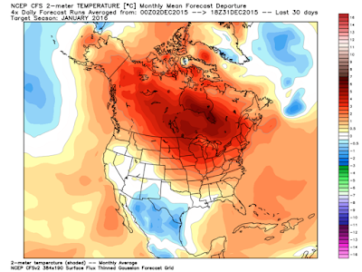
With El Nino now in full swing, we're looking for generally cooler and wetter than normal weather conditions across southcentral Texas as we move into January and February.

The image below shows the latest "Climate Forecast Model" prediction of temperature anomaly (departure from normal) for North America for the month of January (and the map looks much the same heading into February):

CFS January Temperature Departure from Normal (Forecast)
Note that much of southcentral Texas is in the lighter blue shadings, which indicates colder than normal conditions are likely this month.  We agree with this general forecast based on present and expected conditions.

In case you're keeping track - the average high and low temperatures in Austin in January are 60° and 40° F, respectively and are 65° and 45° F, respectively, in February.

The precipitation outlook from the same model also places much of Texas, including our local area, in the "above normal" range for January (and the map looks much the same heading into February):

CFS January Precipitation Departure from Normal (Forecast)
FWIW, the normal rainfall total for Austin in January is 1.89 inches.  The normal rainfall in February is 2.01 inches.

A popular question recently has been "will we see more bad winter weather days in January and February this year due to El Nino".  The short answer is:  not necessarily...

Just because temperatures will likely average "below normal" during the period doesn't necessarily mean that they'll be cold enough to support more widespread freezing precipitation vs. what we'd normally see in late winter.

The safe bet at this point is that this year we're likely to see at least the "normal" number of potentially icy weather days in January and February, and if conditions come together just right, we may see a bit more activity vs. normal as we head into the latter part of this winter.

Stay tuned here to SCTX Aware and we'll keep you advised on the latest winter weather conditions and forecasts for the local area.

You Can Get Mail!

We'll be putting up blog posts here on the new site, concerning not only pertinent weather information and related items, but also other public safety, preparedness and emergency/risk management related topics.

You can sign up to receive an email alert each time a new blog post is published, which will contain a link to the post.

If you'd like to do that, just go to the "Follow By Email" section on the right hand side of this page (toward the bottom) and enter your email address:


...and the next time a post is made, you'll get an update!

What to Expect on the Weather Front

One of our primary goals here at SCTX Aware is to bring independent, unbiased reporting on significant weather conditions in Williamson, Travis and Hays counties of southcentral Texas.

With that in mind, you shouldn't expect a daily tweet or post about the weather when nothing significant is happening. If something significant is expected to happen during the next 7 days, we'll be sure to let you know about it as soon as the situation becomes clearly defined. For routine, day-in and day-out weather information and forecasts, please refer to the "Forecast" link in the upper right hand corner of the homepage:


In the same menu area you'll also find links to current conditions, an almanac containing historical data (coming soon), and an interactive weather radar application built on the Google Maps platform.

We hope you'll find these tools useful in planning your daily activities around the weather, and we plan to make additional enhancements in the coming days and weeks.

If you have any questions or suggestions, please be sure to let us know!

Welcome Back to the Original SCTX Aware Concept!


Welcome back to SCTX Aware!  

As of today, January 1, 2016, SCTX Aware is being administered once again by two of its original founding members, Ralph Fisk and Rob White.

Ralph is the Director and Principal Consultant at Fisk Consulting, an Austin area firm focused on corporate and personal protection as well as emergency management and risk assessment.

Rob is a meteorologist and the President of WeatherGuidance LLC, an Austin area firm that provides customized, site specific weather information, forecasts and storm warnings to a variety of clients and industries across the U.S. and Canada.

What can you expect from here on out?  We see the group getting back to its original focus of providing detailed, actionable information concerning hazardous weather conditions, public safety and personal protection matters for Williamson, Travis and Hays counties of the Austin Metro area in a totally independent, unbiased way. To that end, we have no ties to any government agencies, nor do we have any media ties or affiliations.

Take a look around the site and let us know what you think.  You'll find links to helpful weather information including current conditions, the local forecast and live radar in the upper right hand corner of the page.  Pertinent safety and security links are coming soon as well, so be sure to check back often over the coming days and weeks as additional features are added!

If you aren't already, please be sure to follow us on twitter and facebook (links are provided at right) for "rapid fire" updates during fast changing situations, and check back here on the main page for more detailed information as well as articles on pertinent topics that fall under our areas of expertise.

In summary, if you're looking for "the bottom line" summary on critical weather and personal safety information for the Austin Metro area (including Williamson, Travis and Hays Counties), we think you're in the right place, and we look forward to providing this information to you for a long time to come!

Thanks again, and we wish everyone the best in 2016!